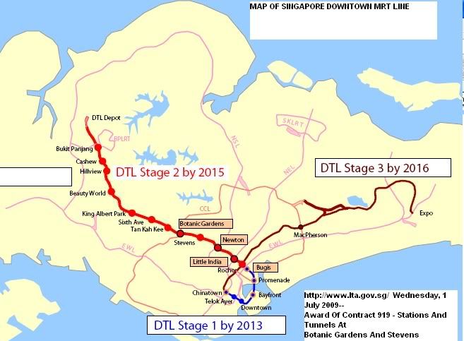
The new Downtown Line seems to snake itself like a 'bus routing'
to capture a largest possible passenger catchment area as
possible without consideration for travel time from point to
point.
Does it not look odd that the new Downtown Line should begin at
Bukit Panjang and run southwards towards Beach Road, and instead of
turning eastward - it loops towards Marina South, then
westward towards Outram before taking on a "North-easterly"
route that parallel the existing NE Line running along
Serangoon-Punggol direction ?
It actually loops around to intersect itself between the
proposed stops at "Little India" and "Bugis" to run
towards Macpherson, and meet the EW Line at the Singapore Expo.
The "North-easterly" route is more like "north-east-east" and
run between the NE Line and the East-West Line - where from the
"Rochor" station it moves to serve the heavily populated along
the "Jalan Besar-Kallang-Macpherson-Paya Lebar-Kaki
Bukit-Bedok Reservoir" corridor.
Anyone from the Bukit Panjang station wishing
to travel to the other end - that stop as tthe
Singapore Expo - will be require an
intermediate change at a connecting station, or ride the entire
journey along a loop circuit.
The MRT is another revenue collecting system for the Government
where it prides itself in generating revenue surplus not from any
export services but from reaping in the money from Singaporean
pockets.
Another service that locks Singaporeans already so dependent on
the Government for a wide variety of essential and non-essential
services that continue to generate profits for the Government.
No wonder it does not blink when US$100 Billion is lost in some
foreign adventures - as there are more in the bigger picture and
over the longer term where it comes from.
Errr, isn't the whole point is to let as much as possible have
access to the MRT?
Is there any particular reasons why the line must be
constructed to benefit people travelling from Bukit Panjang
to Expo in particular?
