2006
Southeast Asian haze
From Wikipedia, the free
encyclopedia
The 2006 Southeast Asian haze was caused by continued open
uncontrolled burning and slash and burn activities in Indonesia,
and has affected several countries in the Southeast Asian region
and beyond, such as Malaysia, Singapore, southern Thailand, and as
far as Saipan. Local sources of pollution do partly contribute to
the increased toxicity, particularly in high-pollution areas such
as ports, oil refineries, and dense urban areas. In the highly
urbanised and industrialised Klang Valley of Malaysia in
particular, the surrounding terrain acts as a natural retainer of
polluted air, aggravating the situation when the haze sets in. The
Klang Valley area includes the financial hub of Kuala Lumpur, the
city of Petaling Jaya, Shah Alam and various other districts and
mukims.

Satellite photograph of the haze
above Borneo
Indonesia
The fires originate mostly in Kalimantan, the Indonesian part of
Borneo, and on Sumatra, where they are set annually by farmers to
clear land ahead of the growing season. Satellite images taken over
Borneo on October 4 showed 561 "hot spots" indicating areas where
fires had been set.
Officials in neighboring countries accuse Indonesian officials of
doing nothing to stop the fires, though forestry ministry officials
said they had firefighters working to douse the blazes on
state-controlled land. However, they conceded, most of the fires
were on private land.
The fires have closed schools, delayed and cancelled airline
flights, disrupted shipping and forced Indonesians to don face
masks. Cities affected include Pontianak, West Kalimantan,
Palangkaraya, Central Kalimantan and Pekanbaru, Riau. The haze was
blamed for a Mandala Airlines flight skidding off the runway upon
landing at Balikpapan, East Kalimantan on October 3, when
visibility was reported at around 400 meters. It has caused
breathing problems for people in the Riau Islands and in Jambi
Province.
Malaysia
Menara Kuala Lumpur was barely visible.The effects of the haze
started in early July and affected the northern Malaysian states
severely. However, the haze had cleared substantially throughout
Peninsular Malaysia from August 29, 2006 due to raining season. The
rain reduced the number of hotspots throughout Sumatra and the
Malay Peninsula. On the August 30, 2006, The Star reported that
Kuala Lumpur would be free of haze during the Merdeka Day. In the
late evening just before midnight on the August 31, 2006,
visibility in the Klang Valley was recorded to be very good.

The business district of Kuala
Lumpur in the evening of September 29, 2006. Menara Kuala Lumpur
was barely visible.
Unfortunately, the haze returned again in late September. This was
due to a change of wind direction towards the south west partially
caused by Typhoon Xangsane. The worst hit place was Kuching, where
the Air Pollution Index (API) nearly reached 300, which borders the
hazardous category of the API. The worst affected area in
Peninsular Malaysia is Johor Bahru which recorded an API of 150 on
October 7 and October 8. For now, many people are wearing masks to
prevent themselves from inhaling excessive amounts of haze. On
October 7, visibility in parts of East Malaysia fell to 300 metres.
On or about October 9, the worst of the haze seemed to be in the
state of Negeri Sembilan, where visibility in Sepang fell briefly
to 500 metres and the API in Nilai reached 198. Shortly thereafter
changing winds caused conditions to improve rapidly. Sarawak has
started cloud seeding attempts to try to encourage rainfall that
will help relieve the haze.
Singapore
Singapore was largely spared from the haze, recording PSI at
moderate levels until 8 a.m., October 7, 2006, when the 3-hour PSI
reading breached the 100 mark and entered unhealthy levels for the
first time in the year. At 10 a.m., it hit 130, the highest in
three years, before subsiding to 80 at 4 p.m. and climbing rapidly
to 150 at 9 p.m, before ending the day at 136, the worst since
1997. The highest 3-hour average PSI ever recorded was 226 in
September 1997.
Thailand
In July, the southern Thai provinces of Pattani and Satun suffered
an on and off bout of smog, with the levels of pollutants in Satun
being high enough to constitute a health hazard. In all, seven
provinces were affected by the haze in July and August.
Haze was again reported on October 6, with respiratory illnesses
and eye irritation reported in Narathiwat. Visibility and air
quality were also affected in Songkhla, Satun and Yala. Health
warnings were issued and surgical masks were issued to residents.
Three days later, meteorological officials reported that the haze
had thinned to almost normal visibility.
NASA MODIS imagery of
fires
Click for
bigger image
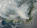
Fires on Borneo, especially
Kalimantan, and the haze caused. Image captured October 5, 2006 by
the Terra MODIS satellite.

Fires on Sumatra and the
resulting haze. Image captured October 4, 2006 by the Aqua MODIS
satellite.
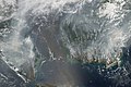
An image captured on October 1,
2006 by the Aqua MODIS satellite that shows the extent of the fires
and resulting haze.


