Vogelsberg
Mountains
The Vogelsberg Mountains are a group of low
mountains in central Germany, located in the middle of the state of
Hessen. They are the product of ancient volcanic activity and are
separated from the Rhön Mountains by the Fulda River and its
valley.

Vogelsberg
Mountains
Arising approximately 19 million years ago, the Vogelsberg,
Germany's only shield volcano, is also Central Europe's largest
basalt formation, consisting of a multitude of layers which, having
flowed over each other, fall downward from their peak in
ring-shaped terraces to the base.
The main peaks of the Vogelsberg are Taufstein, 773 m (2,536 ft),
and Hoherodskopf, 763 m (2,503 ft), both now enclosed in a national
park, the Hoher Vogelsberg Nature Reserve.
Issue #362
Storegga Slide
The three Storegga Slides count among the largest
recorded landslides. They occurred under water on the edge of
Norway's continental shelf (Storegga is Norwegian for "the Great
Edge") in the Norwegian Sea, 100 km north west of the Møre coast,
where an area the size of Iceland slid, causing a megatsunami in
the North Atlantic Ocean. The latest incident occurred around 6100
BC. In Scotland, traces of this tsunami have been recorded.

Location of the Storegga
Slide
As part of the activities to prepare the Ormen Lange natural gas
field, the incident has been thoroughly investigated. One
conclusion is that the slide was caused by material built up during
the previous ice age, and that a reoccurrence would only be
possible after a new ice age. This conclusion is supported by
numerous exhaustive published scientific studies.
Facts and arguments supporting such conclusion were made public in
2004. Earlier it was concluded that the development of the Ormen
Lange gas field would not significantly increase the risk of
triggering a new slide. A new slide, potentially larger than
Denmark in area, and 400 m to 800 m high, would trigger mega
tsunamis that would be devastating for the coast areas around the
North Sea and the Norwegian Sea.
Issue #363
Menara Kuala
Lumpur
The Menara Kuala Lumpur (or Kuala Lumpur Tower in English) is a
tall tower in Kuala Lumpur, Malaysia built in 1995. It is used for
communication purposes and features an antenna that reaches 421 m
(1,381 ft), which currently makes it the fifth tallest tower in the
world. The roof of the pod is at 335 m (1,099 ft). The rest of the
tower below has a stairwell and an elevator to reach the upper
area, which also contains a rotating restaurant, providing diners a
beautiful view of the city. Races are organised yearly where
participants race up the stairs to the top.

Menara Kuala
Lumpur
Construction
The construction of Menara Kuala Lumpur which began on October
1991, was a 3-phase process. The first phase was the widening of
Jalan Punchak and the excavation of soil from the construction
site. This phase went on until August 15, 1992.
On July 6, 1992, the second phase began with the construction of
the foundation and basement of the tower. Approximately 50,000
cubic meters of concrete were continuously poured for 31 hours thus
setting a record in the Malaysian construction industry. The
foundation work, requiring no piling, was completed by April 15,
1993.
The third phase was the construction of the 'superstructure' which
began in May 1993. The tedious construction of the tower started
with the erection of the tower shaft, then the tower head. As the
finishing touches to the tower head were being done, the
construction of the touristic building began.
The touristic building is adomed with designs that reflect the
Malaysian Islamic culture. The main lobby of the upper ground floor
is decorated with exquisite glass-clad domes that sparkle like
giant diamonds. These domes were designed and arranged in the form
of the Muqarnas by Iranian craftsmen from Isfahan.
On September 13, 1994, Prime Minister, YAB Dato Seri Dr. Mahathir
bin Mohamad performed the Topping-up Ceremony where the antenna
mast was installed, thus marking the final height of the tower, 421
meters above the ground. Lastly installation of the facilities and
amenties was executed to ensure comfort and safety.
Menara Kuala Lumpur was officially opened by the Prime Minister on
October 1, 1996. Among the distinguished guests to the Tower were
the Yang di-Pertuan Agong Tuanku Jaafar, Raja Pemaisuri Agong
Tuanku Najihah, the wives of the Sultan of Brunei, DYMM Paduka Seri
Baginda Raja Isteri Pengiran Anak Hajah Saleha and DYTM Pengiran
Isteri Hajah Mariam.
Facts
Menara Kuala Lumpur is the fifth tallest telecommunication tower in
the world (after the CN Tower Canada, Ostankino Tower Russia,
Oriental Pearl Tower China, Borj-e Milad Iran). Built to enhance
the quality of telecommunication services and the clarity of
broadcasting, Menara Kuala Lumpur represents the symbol of Kuala
Lumpur, the Garden City of Wondrous Lights.
The structure is divided into 5 basic sections:
1. The foundation base houses 3 basement floors for safety
purposes, storage and maintenance work.
2. The touristic building bears the administration office, souvenir
shops and the 146 meters pedestrian mall with cascading
pools.
3. The tower shaft comprises 22 levels with 4 elevators and flights
of stairs with a total of 2,058 steps.
4. The tower head holds the public observation platform (276 m) and
revolving restaurant as well as the telecommunication and
broadcasting stations.
5. The antenna mast crowns the tower and is specially utilized for
telecommunication and broadcasting transmissions.
When constructing Menara Kuala Lumpur, the builders took special
care to construct a retaining wall around a 100 year old Jelutong
tree (Dyera Costulata).
To conserve the tree's position, the tower was moved at a cost of
RM430,000 to avoid felling the monumental tree, which is found near
the pedestrian mall.
Issue #364
Acadia National
Park
Acadia National Park preserves much of Mount
Desert Island, and associated smaller islands, off the Atlantic
coast of Maine. The area includes mountains, an ocean shoreline,
woodlands, and lakes. In addition to Mount Desert Island, the park
comprises much of the Isle au Haut, a small island to the southwest
of Mount Desert Island. A portion of Schoodic Peninsula on the
mainland is also part of the park. In total, Acadia National Park
consists of 30,300 acres (123 km²) on Mount Desert Island, 2,728
acres (11 km²) on Isle au Haut and 2,266 acres (9.2 km²) on the
Schoodic Peninsula.

Acadia National
Park, located near Bangor and Bar Harbor,
Maine.
History
The park was created as Sieur de Monts National Monument on July 8,
1916, administered by the National Park Service. On February 26,
1919, it became a national park, with the name Lafayette National
Park in honor of the Marquis de Lafayette, an influential French
supporter of the American Revolution. The park's name was changed
to Acadia National Park on January 19, 1929.

Bass Harbor Head Light, in the
park.
The town of Bar Harbor is located on the northeast corner of the
island. Cadillac Mountain on the eastern side of the island is a
famous tourist destination because it is one of the first places in
the United States to see the sunrise. Miles of scenic carriage
roads were originally built by John D. Rockefeller, Jr. with great
sensitivity to the trees and contours of the land.
Issue #365
Bay of Green
Bay
The Bay of Green Bay is an arm of Lake Michigan.
It is located on the south-west coast of Michigan's Upper Peninsula
and the east coast of Wisconsin. It is separated from the rest of
the lake by the Door Peninsula in Wisconsin, the Garden Peninsula
in Michigan, and the chain of islands between them. The Bay of
Green Bay is some 120 miles long, with a width ranging from about
10 to 20 miles. At the head of the bay is the city of Green Bay,
Wisconsin, where the Fox River enters the bay. The Leo Frigo
Memorial Bridge (formerly known as the Tower Drive bridge) spans
the point where the bay ends and the Fox River begins. The bay is
navigable by large ships.

Bay of Green
Bay
Unlike many other bays, the bay is officially named after the city,
not vice-versa; hence the name Bay of Green Bay.
The bay was named Baie des
Puants (literally, "Stinky Bay") during the French regime as
attested by many French maps of the 17th and 18th centuries.
Issue #366
Mayon Volcano
Mayon Volcano is a volcano in the Philippines. It
is found in the province of Albay in the Bicol Region. Its almost
perfectly-shaped cone is considered by many people to be more
beautiful than Mt. Fuji in Japan. A few kilometres to the south of
the volcano is Legazpi City.

Mayon
Volcano
Elevation: 2,462 metres (8,077 feet)
Location: Albay, Philippines
Coordinates: 13°15'24"N, 123°41'6"E
Type: Stratovolcano
Last eruption: 2004
Mayon is classified by volcanologists as a stratovolcano (composite
volcano). Its symmetric cone was formed through alternate
pyroclastic and lava flows. Mayon is the most active volcano in the
country, having erupted around 50 times for the past 400
years.
The most destructive eruption of Mayon occurred on February 1,
1814. Lava flows buried the town of Cagsawa and 1,200 people
perished. Only the belltower of the town church remained. It is
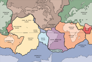
located between the Eurasian and the Philippine Plate and is a
destructive plate boundary. Where a continetal plate meets an
oceanic plate it forces the denser oceanic plate down, pushing
magma up.
Issue #367
Barbary Coast
The Barbary Coast, or Barbary, was the term used by
Europeans until the 19th century to refer to the coastal regions of
what is now Morocco, Algeria, Tunisia, and Libya. The name is
derived from the Berber people of north Africa. In the West, the
name commonly evokes the Arab slave traders based on that coast,
who captured and traded slaves from Europe and sub-Saharan Africa.
It also evokes the Barbary pirates, based on the North African
coast, who attacked shipping in the Mediterranean and North
Atlantic.

Barbary
Coast
"Barbary" was almost never a unified political entity; from the
sixteenth century onwards, it was divided into the familiar
political entities of Morocco, Algeria, Tunisia, and the no longer
extant Tripolitania, and before that it was usually divided between
Ifriqiya, Morocco, and a west-central Algerian state centered on
Tlemcen or Tiaret, although powerful dynasties such as the
Almohads, and briefly the Hafsids, occasionally unified it for
short periods. However, from a European perspective its "capital"
or chief city was often considered to be Tripoli, in modern-day
Libya, although Algiers, in Algeria, and Tangiers, in Morocco, were
also sometimes seen as its "capital" by Europeans of the era.
The first United States military action overseas, executed by the
U.S. Marines and Navy, was the storming of Derna, Tripoli in 1805
in an effort to bolster diplomatic efforts in securing both the
freedom of American prisoners and an end to piracy on the part of
the Barbary state.
Issue #368
Oil field
An oil field is an area with an abundance of oil
wells extracting petroleum (oil) from below ground. Because the oil
reservoirs typically extend over a large area, possibly several
hundred kilometres across, full exploitation entails multiple wells
scattered across the area. In addition, there may be exploratory
wells probing the edges, pipelines to transport the oil elsewhere,
and support facilities.

Drilling rig in a small
oil field near Sarnia, Ontario in
2001
Because an oil field may be remote from civilization, establishing
a field is often an extremely complicated exercise in logistics.
For instance, workers have to work there for months or years and
require housing. In turn, housing and equipment require electricity
and water. Pipelines in cold areas may need to be heated. Excess
natural gas needs to be burned off if there is no way to make use
of it, requiring a furnace and stacks, and pipes to carry it from
well to furnace.
Thus, the typical oil field resembles a small self-contained city
in the midst of a landscape dotted with drilling rigs and/or the
pump jacks known as "nodding donkeys" because of their bobbing arm.
Several companies, such as Bechtel, Esso, Schlumberger Limited,
Baker-Hughes and Halliburton, have organizations that specialize in
the large-scale construction of the infrastructure and providing
specialized services required to operate a field profitably.
More than 40,000 oil fields are scattered around the globe, on land
and offshore. The largest are the Ghawar Field in Saudi Arabia and
the Burgan Field in Kuwait, with more than 60 billion barrels (10
km³) estimated in each. Most oil fields are much smaller. According
to the US Department of Energy (Energy Information Administration),
as of 2003 the US alone had over 30,000 oil fields.
In the modern age, the location of oil fields with proven oil
reserves is a key underlying factor in many geopolitical
conflicts.
Issue #369
Transylvanian
Plateau
Transylvanian Plateau is a plateau in central
Romania almost entirely surrounded by the Eastern, Southern and
Romanian Western branches of the Carpathian Mountains.

Transylvanian
Plateau
The Transylvanian Plateau, the Carpathian Mountains, and the
lowlands in Western Romania are characterized by continental
climate. Temperature varies a great deal in the course of a year,
warm summers are contrasted by very cold winters. These flatlands
have the country's best farmland and most of its cities and towns.
Vast forests cover parts of the Transylvanian Plateau and the
mountains. The mountains (3,000 to 6,000 ft) are all part of the
Carpathian Mountain System.
Issue #370
John Cabot
Giovanni Caboto (c. 1450
c.1499), known in English as John Cabot, was an
Italian navigator and explorer. He is commonly credited as the
first early modern European to discover the North American
mainland, in 1497.

John Cabot gazes
across Bristol Harbour.
Cabot's date and place of birth are uncertain. The date is
projected to be around 1450, and his place of birth is variously
stated to be Genoa, Gaeta, or sometimes Chioggia. It is known at
any rate that in his youth he moved to Venice, a few miles from the
last mentioned town, and became a Venetian citizen.
Like other Italian explorers of the era, such as Christopher
Columbus (Cristoforo Colombo), Cabot made another country his base
of operations. For Cabot it was England, so his explorations were
made under the English flag. The voyage that saw him and his crew
discover the North American mainland the first Europeans known to
do so since the Vikings took place in 1497, five years after
Columbus' discovery of the Caribbean. Again, like Columbus, Cabot's
intention had been to find a westerly sea route to Asia.
It was probably on hearing of Columbus's discovery of 'the Indies'
that he decided to find a route to the west for himself. He went
with his plans to England, because he incorrectly thought spices
were coming from northern Asia; and a degree of longitude is
shorter the further one is from the equator, so the voyage from
western Europe to eastern Asia would be shorter at higher
latitudes.
King Henry VII of England gave him a grant to go on "full and free
authoritie, leave, and power, to sayle to all partes, countreys, a
see as, of the East, of the West, and of the North, under our
banners and ensignes, with five ships ... and as many mariners or
men as they will have in saide ships, upon their own proper costes
and charges, to seeke out, discover, and finde, whatsoever iles,
countreyes, regions or provinces of the heathen and infidelles,
whatsoever they bee, and in what part of the world soever they be,
whiche before this time have beene unknowen to all
Christians."
Cabot went to Bristol to make the preparations for his voyage.
Bristol by then was the second-largest seaport in England, and
during the years from 1480 onwards several expeditions had been
sent out to look for Hy-Brazil, an island that would lie somewhere
in the Atlantic Ocean according to Celtic legends. Some people
think Newfoundland may have been found on (one of) these
voyages.
In 1496 Cabot started a voyage with one ship from Bristol. But, he
got no further than Iceland and was forced to return because of
disputes with the crew. On second voyage Cabot left again with only
one vessel, the Matthew, a small ship (50 tons), but fast and able.
The crew consisted of only 18 people. He departed either May 2 or
May 20, 1497. He sailed to Dursey Head, Ireland, from where he
sailed due west to Asia - or so he thought. He landed on the coast
of Newfoundland on June 24, 1497. His precise landing-place is a
matter of much controversy, either Bonavista or St. John's. He went
ashore to take possession of the land, and explored the coast for
some time, probably departing on July 20. On the homeward voyage
his sailors thought they were going too far north, so Cabot sailed
a more southerly course, reaching Brittany instead of England. On
August 6 he arrived back in Bristol.
The exact location of Cabot's first landfall is still unknown,
because of lack of evidence. Many experts think it was on Cape
Bonavista, Newfoundland, but others look for it in Cape Breton
Island, Nova Scotia, Labrador or Maine. We might never know the
truth. His men may have been the first Europeans on either American
continent since the Vikings: Christopher Columbus did not find the
mainland until his third voyage, in 1498, and letters referring to
a voyage by Amerigo Vespucci in 1497 are generally believed to have
been forgeries or fabrications.
Back in England, Cabot was rewarded with £10, and a patent was
written for a new voyage. Later, a pension of £20 a year was
granted him. The next year, 1498, he departed again, with 5 ships
this time. The expedition made for an Irish port, because of
distress. Except for one ship, John Cabot and his expedition were
never heard from again.
John's son Sebastian Cabot later made a voyage to North America,
looking for the Northwest Passage (1508), and one to repeat
Magellan's voyage around the world, which ended up looking for
silver along the Río de la Plata (1525-8).

The Cabot Tower in the centre of
Bristol, England.
In 1498-1500 a few Portuguese travelers, Miguel and Gaspar
Corte-Real being the most famous participants, visited Greenland,
Labrador and Newfoundland. In 1501-1505 an English syndicate,
consisting of 3 Azoreans and 2 English traders, made voyages to
Newfoundland. From 1504, if not before, Breton, Basque, Portuguese
and English fishermen crossed the ocean to catch fish on the
Newfoundland banks.
Cabot is remembered in Bristol by the Cabot Tower, a 30m tall red
sandstone tower of 1897 (the 400th anniversary of the landing) on
Brandon Hill near the city centre, by a replica of the Matthew
built in the city and by a statue of the explorer on the
harbourside.
Issue #371
Lake Nasser
Lake Nasser (transliterated: Buhayrat Nasir) is a
vast reservoir in southern Egypt and northern Sudan. Strictly,
"Lake Nasser" refers only to the much larger portion of the lake
that is in Egyptian territory (83% of the total), with the Sudanese
preferring to call their smaller body of water Lake Nubia.

View of Lake
Nasser from Abu Simbel
It was created as a result of the construction of the Aswan High
Dam across the waters of the Nile between 1958 and 1970.
The lake is some 550 km long and 35 km across at its widest point,
which is near the Tropic of Cancer. It covers a total surface area
of 5,250 km² and has a storage capacity of some 157 km³ of
water.
The rising waters of the dam required major relocation projects
that were carried out during the 1960s.
Several important Nubian archaeological sites were dismantled block
by block and moved to higher ground, most notably Abu Simbel. The
Sudanese river-port and railway terminal of Wadi Halfa was lost
beneath the waters and a new town was built in its place; and
Egypt's entire Nubian community from the upper reaches of the Nile
numbering several hundred thousand people saw their villages
disappear and were forced to relocate.
The Egyptian name is in honor of President Gamal Abdel Nasser, who
was the mastermind behind the controversial High Dam project.
Rising lake levels through the 1990s resulted in spilling over of
waters into the Western Desert, forming the Toshka Lakes beginning
in 1998.
Issue #372
Gulf of
Khambhat
The Gulf of Khambhat (formerly known as the
Gulf of Cambay) is an
inlet of the Arabian Sea along the west coast of India, in the
state of Gujarat. It is about 80 miles in length, and divides the
Kathiawar peninsula to the west from the eastern part of Gujarat
state on the east. The Narmada and Tapti rivers empty into the
Gulf. The Gulf is shallow and abounds in shoals and sandbanks. The
Gulf is known for its extreme tides, which vary greatly in height
and run into it with amazing speed. At low tide the bottom is left
nearly dry for some distance below the town of Khambhat.

Gulf of Khambhat
on the right. Image NASA Earth Observatory
The Alang Ship Recycling Yard takes advantage of the extreme high
tides of the gulf. Large ships are beached during the twice-monthly
highest tides, and are dismantled when the tide recedes.
The Gulf of Khambhat has been an important center of trade since
ancient times; its ports connect central India to the maritime
trade routes of the Indian Ocean. Bharuch (Broach), Surat,
Khambhat, Bhavnagar, and Daman are historically important seaports.
Bharuch has been important since ancient times; Khambhat was the
gulf's chief port in the Middle Ages, but after the silting of its
harbor, Surat rose to prominence as the most important harbor of
the Mughal empire.
Traces of a neolithic culture have been found submerged in the Gulf
in 2002. A piece of carbonized wood recovered from the area has
been radiocarbon dated to a calibrated age of some 9,500 years. The
finds pre-date the Harappan civilization by at least 4,000
years.
Issue #373
Mountain pass
In a range of hills, or especially of mountains, a
pass (also gap,
notch, col, saddle, bwlch or bealach) is a lower point that allows
easier access through the range. On the route through the range, it
is locally the highest point on the route. Since many of the
world's mountain ranges have always presented formidable barriers
to travel, passes have been important since before recorded
history, and have played a key role in trade, war and
migration.

The Great St. Bernard Pass, still
snowy even in June, has long been a major route through the
Alps.
Topographically, a pass has the general form of a saddle between
two mountains (the elevation as a function of two position
coordinates is mathematically a saddle point). They are often found
just above the source of a river, constituting a sort of "bridge"
over to the headwaters of a different river. Passes may be very
short, consisting of steep slopes to the top of the pass, or
valleys of many kilometers, whose highest point is only
identifiable by surveying.
Roads have long been been built through passes, and more recently
railways. Some high and rugged passes may have tunnels bored
underneath, so as allow faster traffic flow year-round.
The top of a pass is frequently the only flat ground in the area, a
high vantage point, so it is often a preferred site for buildings.
For countries whose borders are delimited by a mountain range, the
pass is typically part of the border, and the facilities likely
include a border control or customs station, and possibly a
military post as well. For passes with roads, it is also customary
to have a small roadside sign giving the name of the pass and its
elevation above mean sea level.
There are thousands of named passes around the world; some are
familiar names, such as the Great St. Bernard Pass (2,473 m) in the
Alps, the Khyber Pass (1,027 m) between Afghanistan and Pakistan,
and the Khardungla Pass (5,359 m) in Jammu and Kashmir, India. The
world's highest motorable pass may be the little known Semo La
(5,565 m) in Tibet.
The word gap is more commonly used in the southern Appalachians,
while notch is more common in New England.
In the Scottish Highlands, the Gaelic term bealach is used.
Issue #374
Harlech Castle
Harlech Castle, located in Harlech, Wales, was
constructed atop a cliff close to the sea (which has since
receded). Begun in 1283 as part of Edward I's second campaign in
North Wales, the castle was part of Edward's "iron ring" of castles
around coastal Snowdonia. Like many of the castles in the area,
Harlech, which took seven years to build, was designed by James of
St. George.

The main gatehouse of
Harlech Castle.
Once constructed, the castle formed a concentric circle, with one
line of defenses enclosed by another. The surrounding cliffs made
it impossible to attack the castle except from the east, which had
a powerfully-defended gatehouse. Scholars also remarked that
Harlech defended "way from the sea", with a fortified stairway that
runs almost 200 feet down to the foot of the rock where the castle
is perched atop. This allowed the castle to have direct access to
ships' supplies, however the tide has since receded so that this is
no longer possible. When the castle was besieged during Madoc ap
Llywelyn's campaign in 1294-1295, this stairway was used to supply
the castle.
In 1404, the castle fell to Owain Glyndŵr, becoming his residence
and headquarters. Four years later, after another long siege,
Harlech Castle was retaken by Prince Henry (later Henry V).
In the Wars of the Roses Harlech was held by Sir Richard Tunstall
as a hold-out Lancastrian stronghold in the first part of Edward IV
of England's reign (1461-1470). It was the last Lancastrian
fortress to surrender when it did so in 1468; it was able to
withstand the seven-year siege through its being provisioned from
the sea. This siege partially inspired the song "Men of
Harlech".
Issue #375
Tidal island
A tidal island is a piece of land that is
connected to the mainland by a natural or man-made causeway that is
exposed at low tide and submerged at high tide. Because of the
mystique surrounding tidal islands the majority of them have been
sites of religious worship, such as Mont Saint Michel with its
Benedictine Abbey. Tidal islands are also commonly the sites of
fortresses, due to their natural fortifications.

St. Michael's Mount at high tide
in 1900.
The former Bennelong Island in Sydney, Australia was developed into
Bennelong Point and is now the location of the Sydney Opera
House.
Issue #376
Lava dome
In volcanology, a lava dome is mound-shaped growth
resulting from the eruption of high-silica lava (usually rhyolite
and/or dacite) from a volcano. It is also known as a plug dome,
although that term is rarely used.

A forested lava
dome in the midst of the Valle Grande, the largest meadow
in the Valles Caldera National Preserve.
The high silica content makes the lava very viscous, so that it
cannot flow very far from its vent before solidifying. Lava domes
are one of the principal building materials of many stratovolcanoes
worldwide. Domes may reach heights of several hundred metres, and
can grow slowly and steadily for months or years. Because
high-silica lava can build more highly and steeply than low-silica
lava (such as basalt), lava domes can be unstable and prone to
collapse. When part of a lava dome collapses while it still
contains molten rock and gases, it produces a pyroclastic flow, one
of the most lethal forms of volcanic event. Ultimately, many
volcanic domes are destroyed by large explosive eruptions.
Some of the world's most famous active lava domes include those at
Mount Merapi in central Java of Indonesia, Soufriere Hills volcano
in Montserrat, and Mt. St. Helens in the U.S. state of Washington.
Lassen Peak in the northern part of the U.S. state of California is
one of the largest single lava domes in the world and has the
distinction of being the only other Cascade volcano besides Mount
St. Helens to have erupted (1914-1921) in the 20th Century.
Issue #377
International Stadium
Yokohama
The International Stadium of Yokohama (Japanese:
Yokohama Kokusai Sougou
Kyougijou) has 73,237 seats, and was inaugurated in March
1998. It is the home stadium of Yokohama F. Marinos of the J.
League.

International Stadium
Yokohama
It hosted three first-round games during the Football World Cup
2002, and the final game between Germany and Brazil was played
there on June 30, 2002 (the game was won by Brazil, 20).
From March 1, 2005, its name was changed to Nissan Stadium
(Japanese: Nissan
Sutajiamu) to reflect the sponsorship of the Nissan Motor
Co.
It hosted some matches of the 2005 FIFA Club World Championship,
including the finals. During the tournament, its name was
temporarily reverted to the original due to FIFA requirements (FIFA
does not recognise sponsorship of stadia at official FIFA
events).
Issue #378
Marlborough
Sounds
The Marlborough Sounds is an extensive network of
sea-drowned valleys at the north of the South Island of New
Zealand.

Sea kayakers in the
Marlborough Sounds.
Geography
Covering some 4,000 km² of sounds, islands, and peninsulas, the
Marlborough Sounds lie at the South Island's north-easternmost
point, between Tasman Bay in the west and Cloudy Bay in the
south-east.
The steep, wooded hills and small quiet bays of the sounds are
sparsely populated, as access is difficult. Many of the small
settlements and isolated houses are only accessible by boat. The
main port is Picton on the mainland, at the head of Queen Charlotte
Sound. It is at the northern terminus of the South Island's main
railway and State Highway networks.
The main sounds, other than Queen Charlotte Sound, are Pelorus
Sound and Kenepuru Sound. Tory Channel is a major arm of Queen
Charlotte Sound, and between them they isolate the hills of Arapawa
Island from the mainland. Other islands in the sounds include
D'Urville Island.
Ferries and marine farms
The Marlborough Sounds are connected with Cook Strait at the
north-east extreme. At this point, the North Island is at its
closest to the South Island, and the inter-island road, rail, and
passenger ferry service between Picton and Wellington travel
through the sounds.
Marine farming is increasingly common, although the wake caused by
fast catamaran vehicular ferry services to the North Island has
been alleged to damage farms, and has resulted in a dispute heard
in the environment court. The fast ferries (which only operate for
the summer season) are restricted to a lower speed in the sounds,
reducing their time advantage over the conventional ferries.
Dangerous waters
The main channels of the Marlborough Sounds have calm water and are
popular for sailing. Cook Strait, however, is infamous for its
strong currents and rough waters, especially when the wind is from
the south or north. Because of this, some of the narrow channels
closer to the Strait are notoriously dangerous. Notable amongst
these is French Pass at the southern end of D'Urville Island, which
has several vortices.
The most notable shipwreck in the sounds is that of the Russian
cruise liner Mikhail Lermontov, which sank in 1986 in Port Gore,
close to the mouth of Queen Charlotte Sound, after striking rocks.
One life was lost in the incident.
Issue #379
Stratocumulus
cloud
A stratocumulus cloud is a cloud belonging to a
class characterized by large dark, rounded masses, usually in
groups, lines, or waves, the individual elements being larger than
those in altocumulus and the whole being at a lower altitude,
usually below 2,400 m (8,000 ft).

A group of stratocumulus
clouds hanging low over the mountain valley seen from the
summit of Mount Kinabalu.
Issue #380
Muir Glacier
Muir Glacier is a tidewater glacier in Glacier Bay
National Park and Preserve in the U.S. state of Alaska. It is
located at 58.917°N, 136.117°W, and is about 3 km (2 miles) wide
and about 80 m (265 feet) tall. It calves or sheds icebergs.

Muir
Glacier
The glacier is named after John Muir, the naturalist, who visited
the area and wrote about it, generating interest in the area and in
its preservation. His first two visits were in 1878 and 1880, at
age 41. During the visits, he sent an account of his visits in
installments to the San Francisco Bulletin. Later, he collected and
edited these installments in a book, Travels in Alaska, published
in 1915, the year he died.
Issue #381
1999 Izmit, Turkey
Earthquake
The Izmit earthquake with a magnitude of 7.4 which
lasted for 45 seconds killed over 17,000 in northwestern Turkey on
August 17, 1999.

The epicentre of the
Izmit earthquake in 1999.
The earthquake had a rupture length of 150 kilometers (93 miles)
from the city of Düzce to all the way into the Sea of Marmara along
the Gulf of Ýzmit. Movement along the rupture was as large as 5.7
meters (18.7 ft). (Reilinger, et al., 2000)
This earthquake occurred in the North Anatolian Fault Zone (NAFZ).
The Anatolian Plate which consists primarily of Turkey is being
pushed west about 2-2.5 cm/yr (0.8-1.0 in), as it is squeezed
between the Eurasian Plate on the north, and both the African Plate
and the Arabian Plate on the south. Most of the large earthquakes
result as slip occurs along the NAFZ or Eastern Anatolian
Fault.
The official number of casualties is about 17,000 although real
numbers are thought to be above 35,000. The rupture passed through
major cities that are among the most industrialized and urban areas
of the country, including oil refineries, several car companies and
navy headquarters and arsenal in Golcuk thus increasing the
severity of the life and property loss.
This quake was predicted using the new discovery Earthquake
storms.
Issue #382
Drakensberg
The Drakensberg ("Dragon Mountains" in Afrikaans)
mountains are the highest in South Africa, rising up at Thabana
Ntlenyana to 3,482 m (11,422 ft) in height. In isiZulu, the
language of the Zulu People, they are uKhahlamba, the "barrier of spears".
In Sesotho they are referred to as Maluti.

The
Drakensberg
They are located in the eastern part of South Africa, running for
some 1,000 km (600 mi) generally southwest to northeast, with a
northwesterly bend forming the northeastern border of Lesotho with
South Africa. They are drained on the west by the Orange and Vaal
rivers, and on the east and south by a number of smaller rivers,
the Tugela being the largest. The range thus separates
KwaZulu-Natal Province from Free State Province, looming over the
nearby coast of Natal.
The highest peak is Thabana Ntlenyana at 3,482 m (11,422 ft). Other
notable peaks include Mafadi at 3,450 m, Makoaneng at 3,416 m,
Champagne Castle at 3,377 m, Giant's Castle at 3,315 m, and Ben
Macdhui at 3,001 m. All of these are in the area bordering on
Lesotho; north of Lesotho the range gradually becomes lower and
less rugged.
Geologically, the Drakensberg is a remnant of the original African
plateau. The mountains are capped by a layer of basalt up to 1,500
m thick, with sandstone lower down, resulting in a combination of
steep-sided blocks and pinnacles. Caves are frequent in the
sandstone, and many have rock paintings by the San peoples.
Snow falls regularly in the winter, while rains and mists can occur
year-round.
Many of the Drakensberg peaks offer challenging mountaineering.
While the major summits have all been conquered, a number of minor
pinnacles have yet to be ascended. Hiking is also a popular
activity. Navigation on long hikes is often aided by GPS receivers,
and current maps distributed by KZN (KwaZulu-Natal) Wildlife uses
the Cape datum as the geodesic reference. GPS users should be
careful to use the correct datum as WGS 84 is not always the
default.
Tourism in the Drakensberg is developing, with a variety of hotels
and resorts appearing on the slopes. Most of the higher South
African parts of the range have been designated as game reserves or
wilderness areas. The uKhahlamba or Drakensberg National Park,
located in KwaZulu-Natal, near the border with Lesotho, was listed
by UNESCO in 2000 as a World Heritage site. The park is also in the
List of Wetlands of International Importance (under the RAMSAR
convention).
The most well known national park in the Drakensberg is the Royal
Natal National Park. It contains the source of the Tugela river,
and includes the 912 m high Tugela Falls, the second highest
waterfall on earth. But it is the Central Drakensberg that offers
tourists the best access to bushman rock art Kamberg and the
largest range of hiking trails.
Issue #383
Virga
Virga is a meteorological term for precipitation
that falls from a cloud but evaporates before reaching the ground.
At high altitudes the precipitation falls mainly as ice crystals
before melting and finally evaporating; this is usually due to
compressional heating because the air pressure increases closer to
the ground. It is very common in desert nations.

Nimbostratus
virga
Virga can cause very interesting weather effects, because as rain
changes from liquid to vapour form, it removes much heat from the
air due to the high heat of vaporization of water. These small
pockets of extremely cold air then descend rapidly, creating a
microburst which can be extremely hazardous to aviation.
Virga also has a role in seeding storm cells, where light particles
from one cloud are blown into neighbouring supersaturated air and
act as nucleation particles for the next thunderhead cloud to begin
forming.
Virga can produce dramatic and beautiful scenes, especially during
a red sunset. The red light can be caught by the streamers of
falling precipitation, while aloft winds push the bottom ends of
the virga so it falls at an angle, making the clouds appear to have
commas attached.
Virga is a Latin word for
a branch or twig, and hence for objects made from it, as a broom, a
staff, or a rod (hence the English word virge).
Issue #384
Northeast Greenland National
Park
Northeast Greenland National Park is the largest
national park in the world, with an area of 972,000 square
kilometres. It is also the only national park in Greenland and in
Denmark. The park encompasses the entire coastline and interior
sections of Greenland, which is the largest island on Earth.
Originally created on May 22, 1974, the park was expanded in 1988
to its present size. In January 1977 it was designated an
international biosphere reserve. It is overseen by the Greenland
Department of Environment and Nature.

Location of Northeast
Greenland National Park in Greenland
Population
The park has virtually no permanent human population. In 1986, the
permanent population of the park was 40, living at Mesters Vig
although 400 sites saw occasional summertime use. These 40 were
involved in cleanup and closeout operations at mining exploration
sites and soon left. Recently only 27 people and about 110 dogs
over-winter in North East Greenland: 2 at Mestersvig, 12 at
Daneborg, members of the Sirius Patrol, the park policing agency,
as well as 8 at the civilian weather station Danmarkshavn and 5 at
the military base Station North.
Fauna
An estimated 5,000 to 15,000 musk ox as well as numerous polar
bears, walrus can be found near the coastal regions of the park.
This is claimed to be 40% of the world population of musk ox. Other
mammals include arctic fox, stoat, collared lemming and arctic
hare. Reindeer left the park in 1900 and wolves in 1934, although
wolves occasionally return. Other marine mammals include ringed
seal, bearded seal, harp seal and hooded seal as well as narwhal
and white whale.
Species of birds which breed in the park include great northern
diver, barnacle goose, pink-footed goose, common eider, king eider,
gyrfalcon, snowy owl, sanderling, ptarmigan and raven.
Issue #385
Robert
Bartlett
Captain Robert Abram Bartlett was a notable ice
navigator and Arctic explorer of the late 19th and early 20th
centuries. Born in Brigus, Newfoundland on August 15, 1875,
Bartlett was the eldest of 10 children and heir to a family
tradition of seafaring men. By the age of 17, he mastered his first
ship and began a life-long love affair with the Arctic. Bartlett
spent over 50 years of his life mapping and exploring the waters of
the Far North and led over 40 expeditions to the Arctic, more than
anyone before or since.

Robert Abram
Bartlett
Bartlett was captain of the Roosevelt and accompanied Commander
Robert Peary on his attempts to reach the North Pole. Bartlett was
awarded the Hubbard Medal of the National Geographic Society for
breaking the trail through the frozen Arctic wastes to within 130
miles of the pole; yet he was excluded from the final exploring
party possibly due to a rivalry between the two men. Bartlett had
taken a ship further north than anyone before him and was the first
person to sail north of 88° N lattitude.
In 1914, Bartletts leadership in the doomed Karluk Expedition
helped save the lives of most of its stranded participants after
leader Vilhjalmur Stefansson abandoned the expedition. After being
stranded on Wrangel Island for several months, Captain Bartlett
walked 700 miles over the ice from Wrangel Island to Siberia across
the Bering Strait to Alaska to summon help; he received the highest
award from the Royal Geographical Society for his outstanding
heroism.
From 1925-1945, at the command of his own schooner, the Effie M.
Morrissey, Bartlett led many important scientific expeditions to
the Arctic, sponsored by American museums, the Explorers Club and
the National Geographic Society, and also helped to survey the
Arctic for the United States Government during World War II.
Robert Bartlett died on April 28, 1946 in a New York hospital.
Bartlett was struck by pneumonia and could not recover. He is
buried in Brigus, Newfoundland.
The Canadian Coast Guard vessel, CCGS Bartlett is named for Robert
Bartlett. Hawthorne Cottage, Bartlett's place of residence located
within Brigus, is a Canada National Historic Site.
Issue #386